Mapping Urban Heat In Charlotte
Learn more about Charlotte’s Urban Heat Island via our interactive StoryMap:

Read or download the Heat Action Survey Report below:
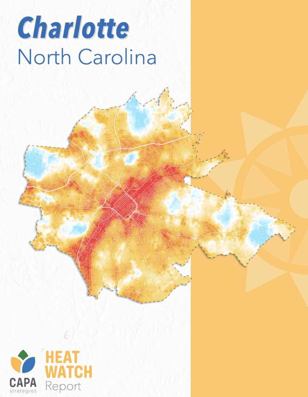
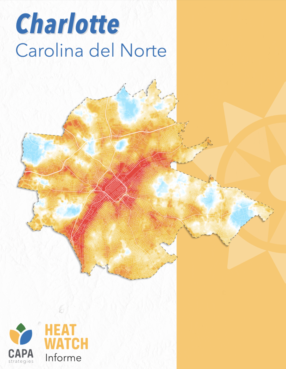
The Heat Watch Report for Charlotte is available online in both English and Spanish:
The raw GIS traverse (vector) data from our mapping campaign day and the resultant raster “heat map” temperature visualizations (raster) are also available for download.
About us
The Charlotte Heat Mappers aim to better understand the varying effects of extreme heat across our urban area and to work with local partners to mitigate its impacts on community health and wellbeing.
Our community partners
The Charlotte Heat Mappers comprise a coalition of community organizations, nonprofits, and government entities across Charlotte and Mecklenburg County as well as state and regional partners:
- Sustain Charlotte
- Action NC
- Sol Nation
- CharlotteEAST
- Charlotte Urbanists
- CleanAIRE NC
- Charlotte Regional Transportation Coalition
- TreesCharlotte
- Catawba Riverkeeper
- Piedmont Promise
- Schiele Museum of Natural History
- Mecklenburg County Park and Recreation Department
- Mecklenburg County Air Quality Division
- Charlotte Mecklenburg Emergency Management Office
- Mecklenburg County Housing Innovation & Stabilization Services
- Mecklenburg County Community Support Services
- City of Charlotte’s Office of Sustainability and Resiliency
- City of Charlotte Landscape Management
- Charlotte Tree Advisory Commission
- UNC Charlotte Department of Earth, Environmental, and Geographical Sciences
- UNC Charlotte Urban Institute
- UNC Charlotte Office of Emergency Management
- UNC Charlotte Department of Public Health Sciences
- Atrium Health/Advocate Health
- State Climate Office of North Carolina
- North Carolina Department of Health and Human Services
- North Carolina Emergency Management
- North Carolina Office of Recovery and Resiliency
- National Weather Service Forecast Office
- Duke Heat Policy Hub
- U.S. Department of the Interior SE Climate Adaptation Science Center
What is an Urban Heat Island?
An Urban Heat Island (UHI) occurs when a city experiences much higher temperatures than nearby rural areas due to a concentration of surfaces and building materials that absorb and hold heat. Learn more at https://climatekids.nasa.gov/heat-islands/
Why is it important to map urban heat?
When combined with conditions such as high humidity, sun exposure, and poor air quality, extreme temperatures can pose serious health risks for individuals, and not all areas and groups are affected equally. To learn more about who faces the greatest risk of heat-related illness, visit https://www.heat.gov/pages/who-is-at-risk-to-extreme-heat
How can I learn more and get involved?
For questions about the Charlotte Heat Mappers, please contact charp@charlotte.edu
In the news
The Charlotte Jewish News Bal Tashchit and Beyond: The Impact of Extreme Heat (August 2025)
WFAE 90.7 Doors open, fans on, trees to come: Charlotte’s heat plan in action (July 1, 2025)
Inside UNC Charlotte UNC Charlotte wins Sustain Charlotte’s Inspiring Nonprofit Award (May 5, 2025)
NC Health News Charlotte strives to tackle extreme heat, energy costs and increase sustainability in underserved communities (December 27, 2024)
WFAE 90.7 ‘Charlotte is hot everywhere,’ summer heat study finds. But there are differences (November 29, 2024)
Qcitymetro Charlotte study reveals hottest areas of the city (November 22, 2024)
WSOC TV9 Data reveals some parts of Charlotte are hotter than others (November 22, 2024)
WFAE 90.7 As heat broils the city, Charlotte Heat Mappers seeks out the hottest neighborhoods (July 18, 2024)
WSOC TV9 Mapping out Charlotte’s hot spots to understand the urban heat island effect (July 14, 2024)
The Charlotte Observer Tracking inequality: Charlotte group to survey neighborhoods to find where it’s hottest (July 13, 2024)
The New York Times ‘More Heat, More Often’: Temperature Records Keep Breaking (July 12, 2024)
WFAE 90.7 As sweltering temperatures continue, how to stay healthy and prepare for the future (July 10, 2024)
WSOC TV9 Scientists and volunteers are mapping Charlotte’s hot spots this summer (June 14, 2024)
WCNC UNC Charlotte leads ‘heat mapping’ campaign in Charlotte (May 6, 2024)
Queen City News Study is attempting to find hottest places in Charlotte (May 2, 2024)
The Charlotte Post How hot? Initiative measures, maps extreme temps, risk (April 25, 2024)
Collegiate Standard Charlotte Heat Mappers Lead Initiative To Map Heat Across The City (April 18, 2024)
The Charlotte Observer What are Charlotte’s hottest spots? Survey intends to reveal dangerous ‘heat islands’ (April 16, 2024)
WFAE 90.7 Charlotte selected to join federal study to find urban heat islands (April 16, 2024)
Inside UNC Charlotte UNC Charlotte Researchers to Lead Community Science Heat Mapping Campaign (April 16, 2024)
To learn more about the importance of mapping urban heat, the development of Charlotte’s 2024 community science heat mapping campaign, and steps our city, communities, and individuals can take to mitigate the impacts of urban heat, view the slide deck below: